
In recent decades, technology has revolutionized the world in many ways. Businesses are increasingly leveraging emerging technologies to create new business models, develop future strategies, enhance product positioning, and add capabilities that help them adapt to the ever-changing competitive business landscape.
For many years, organizations across the globe have relied upon technology solutions to improve efficiencies through automation in their business operations. Today, technology has evolved to become a core differentiator for any organization. Organizations are constantly looking out for new technology solutions that help enhance productivity, reduce operation costs, automate processes, provide data analytics and strategic insights for decision making. As a result, to ensure higher business value to their customers and stay relevant in the market, it is becoming imperative for Independent Software Vendors (ISVs) to constantly innovate to add new functionalities to their existing solutions and build new software applications. This means ISVs must adopt emerging technologies that foster enhanced presence within their customer base and accelerate market growth as well.
Geographic Information System (GIS) has gained recognition as one of the most enabling technologies across the IT industry. GIS is a framework for gathering, managing, visualizing, and analyzing data; a platform to create workflow capabilities either by geo-enabling existing applications or developing new applications. As per a report by Forbes, 66% of customer organizations rank location intelligence and GIS as critical for their revenue growth strategy. The business need for spatial-enabled solutions, is creating a multitude of new business opportunities for ISVs.
One of the leading ISVs, SATRA Infrastructure Management Services Pvt. Ltd., an Infrastructure and Asset Management solution provider, adopted a GIS-based approach to develop a system that manages and maintains the smooth workflow of their road and highway asset management solution. GIS facilitated the development of a powerful database and analytical system that stores, manages, and analyses asset data (spatial and non-spatial) on roads and highways, structures, railways, power distribution lines, etc. thereby meeting the requirements of asset owners, managers, and consultants.
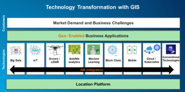
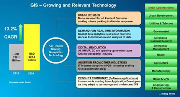
Another advantage of GIS is its ability to integrate with emerging technologies such as Big Data, IoT, 3D, and ML/AI. A study by Geospatial Media estimates the Global Geospatial Market to be $502.6 Billion by 2024. It will witness growth driven by increased penetration of the Internet of Things (IoT), integration of geospatial technology with mainstream technologies, and significant advancements in geospatial analytics with the introduction of artificial intelligence and big data. ISVs use a variety of data models in their applications for deeper insights in the captured data. Adding a location component could reveal patterns and trends for better business understanding. GIS integrates all types of data and brings the context of location (The Science of Where) in applications to help businesses gain actionable insights.
Since GIS allows analysis of data, data intelligence compiled from Geo-enabled applications can help ISVs deliver more value to their customer enabling them to make informed & intelligent business decisions. Esri, the global market leader in geographic information system (GIS) software, location intelligence, and mapping, offers ArcGIS solutions that improve operations and business results. Esri’s ArcGIS platform provides technology and workflow automation tools that are an efficient and easy way to automate business processes. When harnessed, ISVs can build desktop, web, and mobile applications on the GIS platform. Not only this, the ArcGIS platform also provides the ability to create seamless integration with other enterprise applications and systems thereby helping ISVs create an end-to-end process automation solution for their customers. GIS provides the following functionalities:
- Strengthen business processes; empower end-users
- Streamline complex business processes
- Automate tasks with guided end-user interactions
- Automate reporting as per user requirements
- Display guided and step-by-step interactions for users
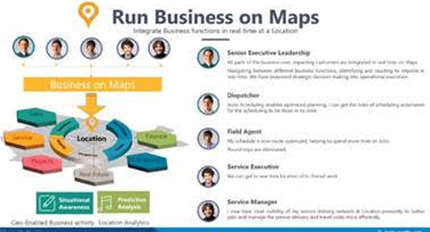
As GIS technology continues to add value to business strategies, ISVs need to look at ways to establish relevant partnerships to capitalize on exponential technologies. Saartha Labs, a Start-up ISV, also sought a GIS-based approach to integrate business operations on maps. This required integrating GIS and SAP to offer a solution that enabled its customers to implement location intelligence in their ERP, CRM, and SCM systems. GIS is adding significant value to their customers – offering better visibility on business operations referring to updates concerning every department, asset maintenance, work orders, scheduling jobs, monitoring, and analyzing asset operations on maps.
Intelligent business decisions and greater insights driven by GIS can be a boon for ISVs in their quest for solutions, driven by technology, that deliver a higher ROI to their customers. ISVs in India have an opportunity to be part of a growing GIS Ecosystem. At Esri India, we offer a comprehensive platform for ISVs to build & deploy apps leveraging APIs, SDKs for web, native & mobile platforms; industry-wide solution templates of ArcGIS; along with business & technical consultancy.
With access to the right GIS technical expertise, tools and superior product knowledge – ISVs will not only be able to drive their business growth but also stand out in the growing and competitive Global Software Application Product market.